The 7-day Machame Route itinerary is carefully curated to offer an immersive and fulfilling experience for climbers seeking to conquer the majestic peak of Mount Kilimanjaro. This renowned route is celebrated for its diverse landscapes, gradual ascent profile, and higher success rates, making it a preferred choice for many adventurers. Designed to optimize acclimatization and ensure the well-being of climbers, this trek incorporates strategic rest periods and extended hiking durations, allowing participants to adapt to the increasing altitude and challenging conditions of the mountain.
The journey commences with the arrival in Tanzania, where climbers are greeted by the warm hospitality of the local staff and guides. After settling into their accommodations in Moshi or Arusha, participants are briefed about the upcoming expedition, including the route, safety measures, and essential equipment required for the climb. This orientation sets the tone for the adventure ahead, fostering a sense of camaraderie and determination among the climbers.
As the trek begins, the initial phase takes climbers through the verdant rainforests surrounding the Machame Gate. The dense foliage and diverse flora create an enchanting backdrop, accompanied by a symphony of exotic birds and wildlife. This serene environment offers a gentle introduction to the trek, allowing climbers to acclimate to the physical demands of the journey while immersing themselves in the natural beauty of the region.
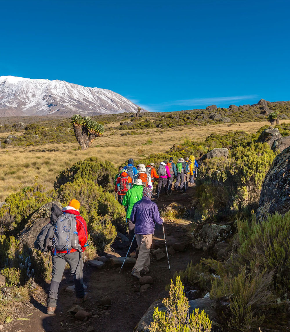
 The ascent continues through varying ecosystems, including the transition from the rainforest to the moorlands. As climbers progress to higher altitudes, the landscape transforms, revealing vast expanses of heather and unique plant species adapted to the harsher conditions. The Machame Route, renowned for its scenic diversity, grants trekkers panoramic views of the picturesque Shira Plateau, an expansive high-altitude plateau with a distinct and awe-inspiring terrain that marks a significant milestone on the journey.
One of the notable highlights of this itinerary is the challenging yet exhilarating traverse of the Barranco Wall. Climbers are presented with a thrilling opportunity to navigate this imposing natural formation, which demands both physical agility and mental fortitude. Scaling the Barranco Wall not only tests the climbers’ endurance but also rewards them with breathtaking vistas of the surrounding landscapes, fostering a profound sense of accomplishment and resilience.
As the trek progresses, the route strategically incorporates rest periods and extended hiking durations, allowing participants to acclimatize gradually. The two-day hike from Barranco to Barafu is a testament to this approach, offering climbers essential time to adapt to the increasing altitude and challenging conditions. This careful acclimatization strategy has significantly contributed to the route’s impressive success rates, providing climbers with the best possible chance of reaching the summit while minimizing the risk of altitude-related illnesses.
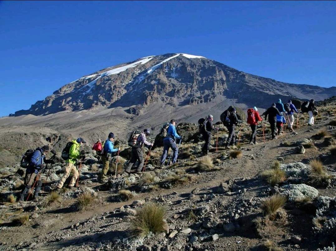
7-day Kilimanjaro Machame Route Summit Day
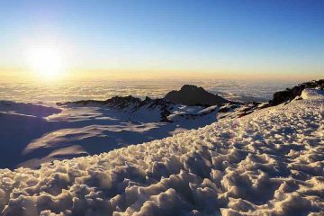
The final leg of the journey culminates in the exhilarating summit attempt, where climbers embark on the ultimate ascent to Uhuru Peak, the highest point in Africa. The summit night is characterized by an awe-inspiring display of stars illuminating the night sky, providing a celestial backdrop for the climbers’ determined pursuit of their goal. As the ascent continues, the freezing temperatures and challenging terrain test the climbers’ endurance and perseverance, underscoring the sheer magnitude of their accomplishment upon reaching the iconic Uhuru Peak.
The moment of triumph at the summit is an emotional and profound experience, marked by a surge of exhilaration and a profound sense of achievement. Climbers are greeted by the breathtaking panoramic views from the summit, offering a rare and unparalleled perspective of the surrounding landscapes and the sheer magnificence of Mount Kilimanjaro. This pivotal moment serves as a testament to the climbers’ unwavering determination, resilience, and spirit, embodying the essence of human perseverance and the triumph of the human spirit over adversity.
Descending from the summit, climbers are enveloped in a profound sense of fulfillment and satisfaction, knowing that they have conquered one of the world’s most formidable peaks. The descent presents its own set of challenges, underscoring the importance of caution and attentiveness during the return journey. The support and guidance of experienced guides and porters are instrumental during this phase, ensuring the safety and well-being of all climbers as they make their way back to the base.
Upon reaching the concluding phase of the trek, climbers are celebrated for their remarkable achievements and presented with well-deserved summit certificates, serving as tangible mementos of their extraordinary accomplishments. The camaraderie and bonds forged during the journey remain indelible, fostering lifelong memories and a profound appreciation for the collective spirit of adventure and exploration.
The 7-day Machame Route itinerary embodies the essence of adventure, resilience, and camaraderie, offering climbers an unforgettable journey of self-discovery and triumph. Through its meticulously planned design, diverse landscapes, and strategic acclimatization approach, this route remains a beacon of inspiration for adventurers seeking to test their limits and embrace the spirit of exploration. Kilimanjaro Trails‘ commitment to providing a safe, immersive, and rewarding experience reflects their dedication to fostering a deep and enduring connection between climbers and the awe-inspiring natural wonders of Mount Kilimanjaro.
Best Time to Climb Kilimanjaro via Machame Route
 Mount Kilimanjaro is generally accessible for climbing throughout the year, but the best times to embark on the Machame Route are during the drier seasons, which typically occur from late June to October and from late December to mid-March. These periods offer relatively clear skies and stable weather conditions, enhancing the overall trekking experience and increasing the chances of a successful summit. Climbers are advised to avoid the rainy seasons, which usually occur from mid-March to early June and from November to early December, as the trails can become slippery and prone to landslides, making the ascent more challenging and potentially hazardous.
Health and Safety Precautions
Prior to undertaking the Kilimanjaro climb, it is imperative for climbers to undergo comprehensive medical check-ups to assess their physical fitness and evaluate their suitability for high-altitude trekking. Adequate preparation, including regular cardiovascular exercises, strength training, and endurance building, is essential to enhance overall fitness levels and ensure optimal performance during the ascent.
It is crucial for climbers to remain vigilant and proactive in managing altitude-related risks, such as acute mountain sickness (AMS) and high-altitude cerebral edema (HACE), by adhering to a gradual ascent profile, staying well-hydrated, and consulting with experienced guides and medical professionals throughout the journey. Additionally, climbers are encouraged to pack essential medications, adhere to a nutritious diet, and prioritize adequate rest to maintain their physical and mental well-being during the challenging trek.
Preparation
Successful preparation for the Kilimanjaro climb via the Machame Route involves comprehensive planning, meticulous gear selection, and rigorous training to ensure climbers are adequately equipped to navigate the diverse terrains and challenging conditions of the ascent. Essential gear includes high-quality trekking boots, moisture-wicking clothing, thermal layers, waterproof outerwear, durable backpacks, and specialized mountaineering equipment, such as trekking poles, harnesses, and crampons.
Climbers should also prioritize the acquisition of essential personal items, including sunscreen, sunglasses, headlamps, first-aid kits, and high-altitude sleeping bags, to guarantee their comfort and safety throughout the expedition. Engaging in pre-departure briefings, physical conditioning programs, and altitude simulation exercises can significantly enhance climbers’ preparedness and fortitude, fostering a sense of confidence and readiness for the challenges ahead.
Unique Features on Machame Route
The Machame Route is renowned for its unparalleled scenic diversity, offering climbers the opportunity to traverse multiple ecosystems, ranging from lush rainforests and expansive moorlands to breathtaking alpine deserts and glacial landscapes. The route presents unique natural features, including the iconic Barranco Wall, a challenging rock formation that demands climbers’ agility and determination as they navigate its imposing terrain. Moreover, the Machame Route provides panoramic views of the picturesque Shira Plateau and the mesmerizing glaciers adorning the upper slopes of the mountain, creating a surreal and awe-inspiring backdrop that encapsulates the profound beauty and grandeur of Mount Kilimanjaro.
Where to Stay during Your 7 Days Machame Route
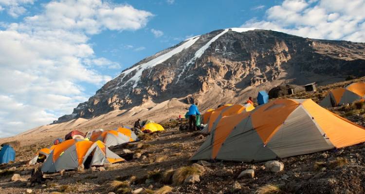
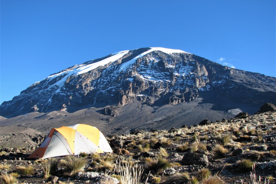
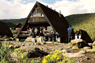
At Kilimanjaro Trails, we ensure a well-organized camping experience for climbers on the 7-day Machame Route. Our premium, high-quality, weather-resistant tents are designed for durability and comfort, standing up to the challenging mountain conditions of Kilimanjaro.
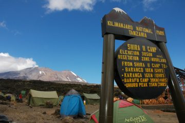
Each night, our experienced support crew sets up these top-tier tents at stunning campsites, including Machame Camp, Shira Cave, Barranco Camp, Karanga Camp, Barafu Camp, and Mweka Camp. These sites are nestled in Kilimanjaro’s diverse landscapes, ranging from lush rainforests to alpine deserts, and offer basic facilities like shared latrines.
We prioritize your comfort on the mountain by providing quality sleeping mats and communal dining tents for meals during your Kilimanjaro climb. This setup blends the adventure of camping with essential amenities, ensuring a memorable and comfortable climb.
As part of our comprehensive package, we includes comfortable accommodations in Moshi or Arusha before and after your climb. You’ll stay in cozy hotels or lodges equipped with modern amenities like hot showers, Wi-Fi, and delicious local and international cuisine.
These pre- and post-climb accommodations provide a relaxing environment to prepare for your ascent or recover after conquering Kilimanjaro. With Kilimanjaro Trails, every detail is covered for an unforgettable climb.
7 days Machame Route Itinerary
Arrival Day: Touch down at Kilimanjaro International Airport
Welcome to your Kilimanjaro adventure with Kilimanjaro Trails! On Day 1, you’ll touch down at Kilimanjaro International Airport, where our team will greet you.
We’ll arrange a comfortable transfer to Arusha, ensuring a smooth start to your climb. Upon arrival, you’ll check into the cozy Arusha Planet Lodge, known for its welcoming atmosphere and modern amenities.
At the lodge, our expert guides will conduct a thorough gear check to ensure you’re fully prepared for the Machame Route. This is a great time to ask questions and finalize your preparations.
Later, enjoy a delicious dinner featuring local and international cuisine, included in your package. Relax and rest overnight at Arusha Planet Lodge, recharging for the exciting climb ahead. Dinner Included.
Transfer from Machame Gate to Machame Camp
Elevation: 1,640 meters (5,380 feet) to 2,850 meters (9,350 feet)
Distance: 11 kilometers (7 miles)
Hiking Time: 5-7 hours
Habitat: Montane forest
Your exhilarating journey begins at the Machame Gate, where you’ll register and commence your ascent. The initial leg winds through the dense, emerald embrace of the montane rainforest. The trail, at times, can be challenging with its uneven terrain and occasional mud patches, so it’s essential to maintain a steady pace and watch your footing. As you trek, the air is filled with the symphony of the forest, alive with the calls of various bird species and the rustling of small mammals. Keep an eye out for colobus monkeys and the unique flora that characterizes this ecosystem. By the day’s end, you’ll arrive at Machame Camp, nestled in the midst of the verdant wilderness, ready to settle in for the night.
Transfer from Machame Camp to Shira Camp.
Elevation: 2,850 meters (9,350 feet) to 3,810 meters (12,500 feet)
Distance: 5 kilometers (3 miles)
Hiking Time: 4-6 hours
Habitat: Moorland
Today’s journey unveils a shift in the landscape as you gradually transition from the enchanting rainforest to the expansive heath and moorland zone. The terrain becomes steeper, demanding a bit more endurance and determination, but the rewards are plentiful. Sweeping vistas of the surrounding landscape, with Kibo Peak occasionally peeking through the clouds, greet you along the way. As you arrive at Shira Camp, the expanse of the high-altitude plateau unfolds before you, offering a breathtaking view of the setting sun and the promise of a spectacular sunrise the following morning.
Shira Camp - Lava Tower to Barranco Camp
Elevation: 3,810 meters (12,500 feet) to 4,630 meters (15,190 feet) (Lava Tower), then to 3,950 meters (12,960 feet) (Barranco Camp)
Distance: 10 kilometers (6.2 miles)
Hiking Time: 6-8 hours
Habitat: Shrubland
Today’s hike serves a crucial role in your acclimatization process, allowing your body to gradually adapt to the increasing altitude. The ascent to Lava Tower is notably challenging, but the panoramic views from this vantage point make it a worthy endeavor. Enjoy a well-deserved rest and a nourishing meal at Lava Tower before beginning the descent to Barranco Camp. As you make your way down, the terrain shifts once again, revealing the distinct beauty of the alpine desert and shrubland. Keep an eye out for unique alpine plants that have adapted to thrive in this harsh environment.
Hike from Barranco Camp to Karanga Camp
Elevation: 3,950 meters (12,960 feet) to 3,995 meters (13,106 feet)
Distance: 7 kilometers (4.3 miles)
Hiking Time: 4-6 hours
Habitat: Alpine desert
The day begins with a thrilling ascent up the renowned Barranco Wall, a challenging yet exhilarating experience that requires some scrambling and a touch of adventure. The reward at the top is a stunning panoramic view of the surrounding landscapes, with the glaciers of the southern icefields coming into sight. After the descent, the path levels out as you traverse the Karanga Valley, offering a moment of respite before the final climb to Karanga Camp. Perched on a rocky ridge, the camp provides a picturesque setting for an evening of relaxation and reflection.
Transfer from Karanga Camp to Barafu Camp
Elevation: 3,995 meters (13,106 feet) to 4,730 meters (15,520 feet)
Distance: 6 kilometers (3.7 miles)
Hiking Time: 4-5 hours
Habitat: Alpine desert
Today’s trek guides you through the stark and otherworldly landscape of the alpine desert, where the sparse vegetation and rugged terrain create an awe-inspiring ambiance. As you approach Barafu Camp, the anticipation of the impending summit push looms large, adding a palpable sense of excitement and apprehension to the atmosphere. Take the time to rest, refuel, and mentally prepare for the demanding endeavor ahead.
Summit Day!, Hike to Uhuru Peak - descend to Mweka Camp
Elevation: 4,730 meters (15,520 feet) to 5,895 meters (19,340 feet) (summit), then to 3,100 meters (10,170 feet) (Mweka Camp)
Distance: Approximately 5 kilometers (3.1 miles) to the summit and back, and then to Mweka Camp
Hiking Time: 10-14 hours for the summit, additional time for the descent to Mweka Camp
Habitat: Arctic (summit), Alpine desert (Mweka Camp)
The early hours of the morning mark the beginning of your summit attempt, a strenuous and demanding undertaking that tests both your physical endurance and mental fortitude. As you ascend through the frigid, otherworldly landscape of the Arctic zone, each step forward brings you closer to the roof of Africa, the summit of Mount Kilimanjaro—Uhuru Peak. The elation of reaching the highest point on the continent, surrounded by the vast expanse of the African plains far below, is an indescribable experience that will remain etched in your memory forever. After savoring this extraordinary achievement, you’ll begin your descent to Mweka Camp, where the stark beauty of the alpine desert offers a striking contrast to the lushness of the rainforest that awaits you.
You will have your evening meal before having your night’s rest.
Descend Mweka Camp to Mweka Gate - Back to Moshi or Arusha
Elevation: 3,100 meters (10,170 feet) to 1,640 meters (5,380 feet)
Distance: 12 kilometers (7.5 miles)
Hiking Time: 4-6 hours
Habitat: Rainforest
Your final day on the mountain is a descent through the rich, emerald embrace of the rainforest, where the air is saturated with the earthy fragrance of thriving plant life. The symphony of the forest comes alive once more as you make your way toward the Mweka Gate, where your exhilarating journey on Mount Kilimanjaro comes to a triumphant close. Receive your hard-earned summit certificates, a testament to your determination and resilience, and bid farewell to the mountain and the incredible team of guides and porters who supported you every step of the way.
Depending on your departure schedule and availability of time, the certificate presentation will be conducted at the Mweka Gate or during a lunch at a local restaurant. You will then be transferred back to Moshi or Arusha town where you will check in back at your lodge for relaxation and later dinner and overnight. All meals included.
If you want to depart this evening, you will be transferred to the Kilimanjaro International Airport for your flight back home. We can arrange a room for a quick shower before heading to the airport for your flight back home.
Departure Day: Transfer to Kilimanjaro International Airport for departure / or safari extension
After breakfast, we’ll arrange a transfer from Planet Lodge to Kilimanjaro International Airport (JRO) for your departure.
If your flight is scheduled for the evening, Kilimanjaro Trails can organize an exciting tour of Arusha city to explore its vibrant markets and cultural highlights.
Alternatively, opt for a day trip to Tarangire National Park or Ngorongoro Crater for a taste of Tanzania’s stunning wildlife.
For those not departing immediately, we can arrange a safari extension, such as our popular 5-day Tanzania safari, to extend your adventure.
Relax or explore with Kilimanjaro Trails before heading home!
If you are short of time and are in good shape, you can attempt summiting Mt Kilimanjaro through the 6-day Machame Route Kilimanjaro climb.
The 7-day Machame Route climb is an unforgettable odyssey that transcends the realms of ordinary adventure. From the vibrant embrace of the montane rainforest to the stark, ethereal landscapes of the alpine desert and the awe-inspiring Arctic zone near the summit, every step is a testament to human resilience and the indomitable spirit of exploration.
As you descend through the lush rainforest on the final day, the echoes of your triumph reverberate through the verdant canopy, a testament to the challenges conquered and the camaraderie forged. Your summit certificate, earned through grit and determination, serves as a tangible reminder of your remarkable feat on the roof of Africa, a testament to the heights achievable through perseverance and a deep connection with nature. The memories woven into the fabric of this remarkable journey will linger long after the descent, a testament to the enduring spirit of adventure that drives us to conquer the greatest peaks, both within and without.
7 Days Machame Route Prices
The cost for climbing Mount Kilimanjaro through the Machame Route for 7 Days starts from USD 2000 per person sharing in a group of at least 6 trekkers. The Price breakdown of 7 Days Machame route for the year 2025 – 2026 is as per the below table;
| Number of Climbers | Price Per Person | Currency |
| 1 | 2770 | USD |
| 2 | 2430 | USD |
| 3 | 2260 | USD |
| 4 | 2150 | USD |
| 5 | 2140 | USD |
| 6 | 1980 | USD |
For a group of more than 6 climbers, please contact our trekking experts, by filling out the inquiry form, and we will get back to you with details as soon as possible.
What is included / Excluded in the 7-Day Machame Route prices
Included in the Package
All transfers (arrival & departure)
Accommodation in Arusha or Moshi prior and after the climb
Return transfer to & from the Mountain
Quality, waterproof, four-season private mountain sleeping tents
Service of professional & well-experienced mountain guides, chef & porters
All entry fees & camping fees
Rescue fees for Mount Kilimanjaro
All meals while on the Mountain (Breakfast, Lunch & Dinner)
Guides, porters, cook salaries,
Kilimanjaro National Park Entry fees
Kilimanjaro Campsite or Hut fees
Quality mess tents with tables and chairs
Large portions of fresh, healthy nutritious food
Clean, purified drinking water
Crisis management and safety procedures
Fair and ethical treatment of porters
Tanzania government value-added tax VAT
Package Excludes
Tanzania Visa
International Airfare
Gratitude/Tips for crews (please tip separately). Check out the Kilimanjaro Tipping Guide
All items of a personal nature (e.g. laundry, telephone, beverages, etc)
Meals not listed above
Insurance if applicable
These prices are for trekking Kilimanjaro for 7 days via the Machame Route, including the accommodation on arrival day at Moshi or Arusha and the last night when you descend from the Mountain.
Single Tent Supplement for the whole trip $35. This is to be paid if you need to use your tent alone while trekking in your group.

Tour Reviews
There are no reviews yet.
Leave a Review