The 6-day Machame Route, affectionately known as the “Whiskey Route,” is one of the most popular paths to the summit of Mount Kilimanjaro, Africa’s tallest peak. Unlike its longer 7-day variant, this 6-day journey is fast-paced, catering to experienced trekkers with a high level of fitness who are seeking adventure and a quicker ascent.
Machame Route – Exceptional Scenery and Vegetation Zones!
As you traverse the Machame Route, you will pass through a diverse range of vegetation zones, starting with lush rainforest, progressing to heath and moorlands, and eventually reaching alpine deserts and the glacial zone near the summit. The 6-day journey is a visual and botanical feast from start to finish, offering constantly changing landscapes and plant life.
6 Days Machame Route – Distance and Elevation
The total trekking distance for the 6-day Machame Route is approximately 62 km or 37 miles. This route takes climbers from Machame Gate, at an elevation of 1,640 meters, to Uhuru Peak, Kilimanjaro’s highest point at 5,895 meters, and then descends to Mweka Gate. Each day involves a substantial elevation change, emphasizing the need for acclimatization.
6-Day Machame Route Acclimatization – Climb High, Sleep Low
The ‘climb high, sleep low’ technique is integral on this route. This strategy, involving daytime ascents followed by a descent to sleep at lower elevations, is a key factor contributing to the route’s high summit success rates by allowing climbers to acclimatize more effectively to the altitude. This 6 days has less acclimatization time than the 7 Days Machame Route, that has a day for hiking high and sleeping low at the Karanga camp.
The Challenge of the Barranco Wall along Machame Route
One of the defining and most memorable features of the Machame Route is the ascent of the Barranco Wall. While it may look intimidating, this section is more of a scramble than a technical climb, and the sense of achievement and the breathtaking view from the top are unforgettable.
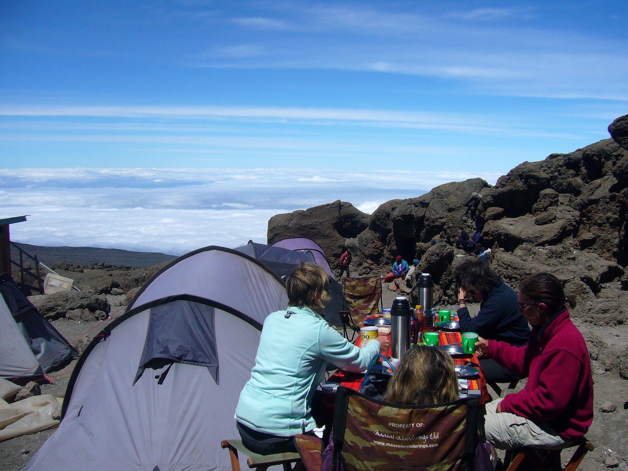
Crowds and Company, Machame is the most popular Mount Kilimanjaro trail
As one of Kilimanjaro’s most popular routes, the Machame can become crowded, especially during peak seasons. For those who enjoy the camaraderie of fellow trekkers, this provides an opportunity for social interaction at the campsites along the trail.
When to Trek: The Best Time to Climb via Machame
July to September is the high season for a reason: the weather is stable and dry, making it the best time to climb Kilimanjaro via the Machame Route. However, Kilimanjaro is a year-round destination, and treks can be successfully undertaken at other times, with proper preparation and gear.
Health and Safety Considerations – Kilimanjaro Trails cares!
Before embarking on this challenging trek, ensuring you are healthy and prepared for the altitude is essential. Comprehensive medical checks and consultations with a healthcare professional about altitude sickness medications are strongly advised.
Is the 6-Day Machame Route for you?
For climbers seeking an unforgettable journey marked by stunning landscapes, a diverse range of vegetation zones, and a sense of accomplishment, the 6-day Machame Route stands as an excellent choice. This route offers both the challenges and rewards befitting an adventure of a lifetime.
Additional information
| Duration | 6 Days |
|---|---|
| Difficulty | Challenging |
| Acclimatization | No |
6-Day Tanzania safari; Detailed itinerary
Arusha/Moshi - Machame Gate to Machame Camp
Elevation: 1,640 meters (5,380 feet) to 2,850 meters (9,350 feet)
Distance: 11 kilometers (7 miles)
Hiking Time: 5-7 hours
Habitat: Montane forest
Embark on your exhilarating expedition at the Machame Gate, registering and stepping into the enchanting embrace of the montane rainforest. The path winds amidst the dense verdant foliage, challenging in parts with uneven terrain and occasional muddy sections. The air resonates with the harmonious medley of diverse bird calls and the rustling of unseen forest dwellers. Keep an attentive gaze for the agile colobus monkeys and the intricate plant life adorning this ecosystem. As daylight wanes, the Machame Camp emerges, nestled in the heart of this vibrant wilderness, providing a welcoming haven to unwind and replenish your energy for the days ahead.
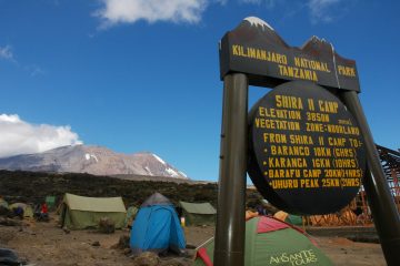
Machame Camp, Hike to Shira Camp
Elevation: 2,850 meters (9,350 feet) to 3,810 meters (12,500 feet)
Distance: 5 kilometers (3 miles)
Hiking Time: 4-6 hours
Habitat: Moorland
Transitioning from the allure of the rainforest, today’s journey introduces the expansive heath and moorland landscape. The inclining path demands heightened endurance, rewarding with sweeping vistas that intermittently reveal the majestic silhouette of Kibo Peak amidst veils of drifting clouds. The arrival at Shira Camp unveils the panoramic high-altitude plateau, offering a stunning visual delight as the sun descends, promising a spectacular sunrise to greet the following morning.
Hike from Shira Camp, through Lava Tower to Barranco Camp
Elevation: Shira Camp at 3,810 meters (12,500 feet), Lava Tower at 4,630 meters (15,190 feet), Barranco Camp at 3,950 meters (12,960 feet)
Distance: Approximately 10 kilometers (6.2 miles)
Hiking Time: 6-8 hours
Habitat: Alpine desert, shrubland, rocky terrain
This exhilarating leg of the journey commences from the enchanting Shira Camp, set against the majestic backdrop of Kilimanjaro’s undulating landscape. As the trek unfolds, the trail leads you through a mesmerizing panorama of undulating terrains and ever-changing vistas. The route weaves its way through the rugged yet mesmerizing high-altitude desert, where the hardy plant life struggles to find a foothold in the rocky terrain. Be sure to pause and marvel at the stark beauty of this alpine desert, a landscape that seems to belong to another world entirely.
The trek continues toward the renowned Lava Tower, an iconic landmark that stands as a testament to the region’s volcanic history. As you ascend towards this towering edifice, the air becomes noticeably crisper, the altitude reminding you of the mountain’s unwavering presence. The challenge posed by the higher altitude is mitigated by the sheer magnificence of the surrounding scenery, which serves as a captivating distraction from the physical exertion.
Upon reaching the Lava Tower, a brief rest provides an opportunity to catch your breath and soak in the awe-inspiring vistas. The sheer scale of the landscape, with its dramatic rock formations and sweeping valleys, instills a profound sense of humility in the face of nature’s grandeur.
The descent from Lava Tower leads you towards the alluring Barranco Camp, nestled in the embrace of a spectacular valley. The trail snakes its way through the Barranco Wall, a thrilling and invigorating scramble that offers a taste of adventure and a tangible sense of accomplishment. As you make your way down the wall, the Barranco Camp comes into view, a welcome sight after the day’s exertions. Nestled amidst the rugged terrain, the camp provides a serene oasis, offering a chance to reflect on the day’s adventures while enjoying the warmth of the campfire and the camaraderie of fellow trekkers.
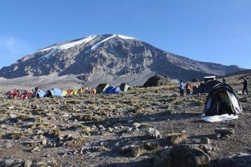
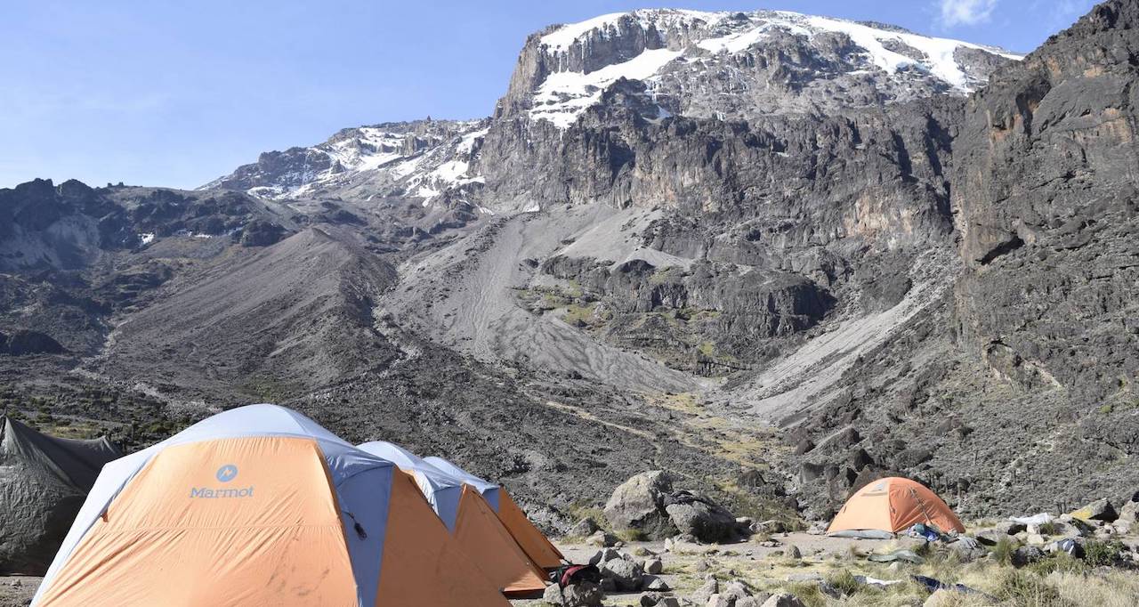
Barranco Camp, Hike through Karanga Camp upto to Barafu Camp
Elevation: Barranco Camp at 3,950 meters (12,960 feet), Karanga Camp at 3,995 meters (13,106 feet), Barafu Camp at 4,730 meters (15,520 feet)
Distance: Approximately 9 kilometers (5.6 miles)
Hiking Time: 8-10 hours
Habitat: Alpine desert, valley, mountainous terrain.
Today’s journey unfolds with a sense of anticipation as you depart from the picturesque Barranco Camp, the echoes of the previous day’s triumph still reverberating in the crisp mountain air. The trail leads you through the timeless Barranco Valley, a breathtaking natural amphitheater encircled by towering cliffs and adorned with hardy alpine flora. As you traverse this awe-inspiring landscape, take a moment to appreciate the intricate tapestry of nature, with its resilient plant life and the occasional glimpse of endemic wildlife.
The route gradually ascends towards the serene Karanga Camp, nestled in a secluded haven that offers respite from the surrounding rugged terrain. As you approach the camp, the distant silhouette of Kilimanjaro’s majestic peak serves as a constant reminder of the ultimate goal looming on the horizon. Take this opportunity to recharge your spirits and replenish your energy, savoring the warmth of the sun and the camaraderie of your fellow trekkers.
The trek continues, leading you along the undulating path towards the renowned Barafu Camp, situated at the foothills of the challenging summit. The landscape undergoes a dramatic transformation, the alpine desert revealing its raw, stark beauty as the vegetation becomes sparser, the air thinner. Despite the increasing altitude and the demanding terrain, the allure of the summit beckons, infusing each step with a renewed sense of purpose and determination.
As you arrive at Barafu Camp, the anticipation of the final ascent to the summit hangs palpably in the air, mingling with a mixture of excitement and trepidation. The camp provides a vital sanctuary for trekkers to rest, refuel, and mentally prepare for the ultimate challenge that awaits. Gather around the campfire, sharing stories and forging bonds that transcend the physical demands of the journey, as you steel yourself for the exhilarating feat that lies just beyond the veil of the night.
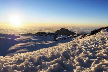
(Summit Day) Barafu - Uhuru Peak - descend to Mweka Camp
Elevation: Barafu Camp at 4,730 meters (15,520 feet), Uhuru Peak at 5,895 meters (19,340 feet), Mweka Camp at 3,100 meters (10,170 feet)
Distance: Approximately 5 kilometers (3.1 miles) to the summit and additional distance for the descent to Mweka Camp
Hiking Time: 10-14 hours for the ascent to Uhuru Peak, additional time for the descent to Mweka Camp
Habitat: Arctic zone, rocky terrain, snow-covered landscapes, alpine desert, rainforest.
As the night fades, and the air hangs heavy with anticipation, you depart from the hushed confines of Barafu Camp, your senses attuned to the weight of the impending challenge. The ascent to the fabled Uhuru Peak, the summit of Mount Kilimanjaro, unfolds gradually amidst the eerie beauty of the Arctic zone. The landscape transforms into a stark, snow-covered terrain, where each step forward is a testament to the unyielding determination of the human spirit. As the altitude steadily rises, the air grows thinner, challenging your physical resilience and mental fortitude.
The final push to Uhuru Peak is an arduous yet exhilarating journey, a testament to your unwavering perseverance and the camaraderie shared with your fellow trekkers. The frigid, otherworldly landscape of the summit serves as a breathtaking backdrop to the euphoria of reaching the highest point in Africa, a moment that transcends mere accomplishment, etching itself as a defining memory for a lifetime.
As you begin the descent towards Mweka Camp, the magnificence of the snow-covered terrain gradually gives way to the rugged beauty of the alpine desert, and eventually, the verdant expanse of the rainforest. Each step downward echoes with the triumph of the summit, mingling with a profound sense of gratitude for the natural wonders witnessed and the resilience discovered within. The journey to Mweka Camp becomes a celebratory descent, a reflection on the challenges conquered and the heights achieved, all amidst the embrace of the vibrant rainforest that signals the journey’s imminent conclusion.
For trekkers seeking a unique and extended experience, the option to stay at Millennium Camp, nestled between the low camp and Mweka Camp, provides an alternative for a more immersive journey. With its spectacular vantage point offering panoramic views of the valley below, Millennium Camp serves as a tranquil retreat, allowing trekkers to bask in the tranquil ambiance and reflect on the remarkable feat accomplished. The choice to spend the night at Millennium Camp adds an extra layer of adventure and allows for a deeper connection with the extraordinary surroundings of Mount Kilimanjaro.
Descend Mweka Camp to Mweka Gate - Transfer back to Moshi
Elevation: Mweka Camp at 3,100 meters (10,170 feet), Mweka Gate at 1,640 meters (5,380 feet)
Distance: 12 kilometers (7.5 miles)
Hiking Time: 4-6 hours
Habitat: Rainforest, lush vegetation, rich biodiversity
The morning sun casts a golden hue over the Mweka Camp, signaling the final leg of your extraordinary journey on Mount Kilimanjaro. As you commence the descent towards Mweka Gate, the vibrant ambiance of the rainforest envelops you, welcoming you with its lush greenery and rich biodiversity. The trail meanders through a captivating symphony of nature, where the air is perfumed with the earthy scent of thriving plant life and the occasional melody of exotic bird calls.
The descent is a testament to the resilience of the human spirit, as each step forward serves as a poignant reminder of the challenges conquered and the heights achieved. The dense canopy above provides a comforting shade, casting fleeting patterns of light and shadow on the trail below. Amidst the tranquility of the forest, take a moment to reflect on the remarkable journey, allowing the sights and sounds of the verdant surroundings to leave an indelible impression on your soul.
As you approach the Mweka Gate, the jubilant atmosphere is palpable, mirroring the sense of accomplishment shared by all those who have journeyed alongside you. Receive your well-earned summit certificates, a testament to your determination and resilience, before bidding a fond farewell to the awe-inspiring Mount Kilimanjaro. The transfer back to the vibrant town of Moshi is a time for trekkers to reminisce about the unforgettable experiences shared, savoring the camaraderie and the memories that will forever be etched in the heart and mind.
The 6-day Machame Route trek on Mount Kilimanjaro offers an unparalleled adventure through diverse landscapes, from the lush rainforests and alpine deserts to the snow-capped summit. Each day presents a new challenge, fostering resilience and camaraderie among trekkers. The triumphant moment at Uhuru Peak, the highest point in Africa, leaves an indelible mark, reminding trekkers of their extraordinary accomplishments. As the journey concludes in the vibrant town of Moshi, the memories of the trek’s awe-inspiring vistas and the shared triumphs serve as a testament to the enduring spirit of exploration and the profound connection with nature’s grandeur. The 6-day Machame Route trek is an experience that transcends the bounds of ordinary adventure, leaving trekkers with a profound appreciation for the remarkable wonders of Mount Kilimanjaro and the unforgettable journey to its iconic summit.
06 Days Machame Route Kilimanjaro Prices
Price depends on number of persons. Please request for your best discounted price depending on how many persons are coming with you.
The Safari includes:
Full board accommodation
All meals as indicated in the itinerary
Transport (4X4 Safari vehicle with fuel)
Full time English speaking driver / guide
Drinking water in the car
Park entrance fees to Serengeti, Tarangire and Lake Manyara National Park, and the Ngorongoro
Safari excludes:
Airport transfers
Visas, passport fees and insurance
All activities listed as ‘optional’ in the itinerary
Personal items
Tips or gratitude gifts to the guides
Soft and alcoholic drinks