Shira Route on Mount Kilimanjaro approaches the mountain from the western side, and it’s very similar to the Lemosho route. The biggest difference is that instead of beginning at the Londorossi Gate, climbers are driven to Shira Gate found at 11,800 feet or 3,600 meters. That way they skip the first section of the climb, though exposes them to a higher risk of altitude-sickness since the route begins at a higher altitude. The route can be completed in ten (10) days.
7 days Mount Kilimanjaro Climb Shira Route – Itinerary
Transfer from Shira Gate, Hike to Simba Camp
Today you will depart from Moshi by car, and drive for approximately four (4) hours to the Londorossi Gate where you will complete all the park entrance formalities and have your equipment organized by the guide and porters. From here you will drive to the Shira gate where this hike will begin. You will follow the Shira route and hike through the huge heather and shrubs until you make it to the Simba camp where you will have your evening meal and spend the night.
Route Plan: Shira Gate to Simba Camp
Elevation: 11,800 feet to 11,800 feet
Distance: 4 kilometers /2 miles
Hiking Time: 1 to 2 hours
Habitat: Heath / moorland.
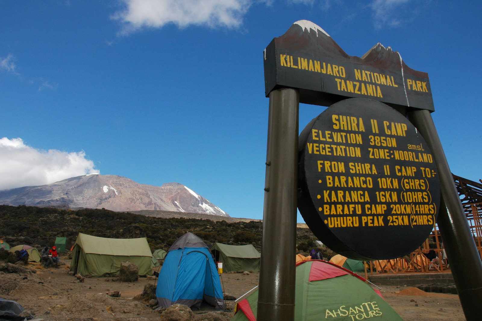
7 days Shira Route; Trek from Simba Camp to Shira 2 Camp.
This is going to be a fairly tiresome day meant for acclimatization. You will explore the volcanic rock-formation and the grassy moorlands of the Shira plateau. Afterwards you will follow the scenic trail to the Shira Cathedral before finally arriving at the Shira 2 Camp where you will spend the night.
Route Plan: Simba Camp to Shira 2 Camp
Elevation: 11,800 feet to 12,500 feet
Distance: 6 kilometer / 4 miles
Hiking Time: 2 hours
Habitat Moved: Heath.
Shira Route Climb from Shira 2 Camp to Lava Tower
Today you will ascend east on a ridge and proceed south eastwards to the Lava Tower also known as ‘Shark’s Tooth’ a very impressive rock formation. . You will make the final descent of the day walking through Senecio Forest until you reach an altitude of 13,000 feet where you will find the Barranco camp where you will have your evening meal spend the night. The time you will spend on the higher altitude will help with acclimatization.
Route Plan: Shira 2 Camp to Lava Tower to Barranco Camp
Elevation: 12,500 feet to 15,190 feet ascent (and of 15,190 feet to 13,044 feet descent)
Distance: 7 kilometers / 4 miles ascent (and 3 kilometers / 2 miles descent)
Hiking Time: 4 to 5 hours ascent (and 2 to 3 hours descent)
Habitat: Alpine Desert.
Trek from Barranco Camp to Karanga Camp
After breakfast, you will descend to the bottom of the Barranco wall, before ascending a steep but not very challenging cliff which is approximately 900 feet high. Once at the top of the wall, you will cross a number of rolling hills until you make a sharp descent into the Karanga Valley. You will make a final ascent to Karanga camp where you will rest, eat and spend the night. This day is shorter to allow acclimatization.
Route Plan: Barranco Camp to Karanga Camp
Elevation: 13,044 feet to 13,106 feet
Distance: 5 kilometers / 3 miles
Hiking Time: 4 to 5 hours
Habitat: Alpine Desert
7 Days Shira Route; Climb from Karanga Camp to Barafu Camp
You will proceed to the junction that connects with the Mweka-Trail, before finally reaching the Barafu camp. This is where the southern circuit which offers various views of the mountain summit ends. You will camp here, rest, have your night meal and get an early sleep as you prepare to make it to the summit the following day. At this point you can actually see the Kibo Peak as well as the Mawenzi peak.
Route Plan: Karanga Camp to Barafu Camp
Elevation: 13,106 feet to 15,331 feet
Distance: 4 kilometers /2 miles
Hiking Time: 4 to 5 hours
Habitat Moved: Alpine Desert.
Summit Day!, Hike to Uhuru Peak - descend to Mweka Camp
You will begin this day’s hike to the summit very early between mid-night and 2:00am. You will hike and head North West and ascend across the thick gravel to Stella Point at an elevation of 18,600 feet found on the rim of the crater. This section of the trail is the most challenging both physically and mentally.
Once at Stella Point, you will have a brief rest and if the weather is good, you will be able to see the most breathtaking sunrise. From this point you will ascend for about an hour traversing the snow covered terrain all the way to the Uhuru peak. The Uhuru summit which stands at a height of 19,341 feet (5,895 meters) is the highest point on Mountain Kilimanjaro and it is considered as the Rooftop of Africa. Actually climbers who are faster will be able to see the sunrise at the Uhuru summit.
After spending some time at the summit resting and taking some photographs, you will begin the descent to the Mweka camp which will be the final destination for the day, making a stopover for lunch at the Barafu camp. During the challenging descent, you will use your trekking poles and gaiters to traverse the loose gravel. The Mweka camp is located on the upper side of the forest, so expect some rainfall or mist in the late afternoon. You will have your evening meal before having your night’s rest.
Route Plan: Barafu Camp to Uhuru Summit to Mweka Camp
Elevation: 15,300 feet to 19,345 feet (and descent to 10,000 feet)
Distance: 5 kilometers ascent (and 12 kilometers descent)
Hiking Time: 7 to 8 hours ascent (and 4 to 6 hours descent)
Habitat Moved: Arctic / rain-forest.
Descend Mweka Camp to Mweka Gate
This is the final day of this 8 Days’ hike on Mt. Kilimanjaro. After your breakfast at Mweka Camp, you will descend to the Mweka- Park Gate where you will be awarded your summit certificates for either the Uhuru peak or Kibo peak. As you descend along the lower part of the forest trail towards the button of the mountain, you will realize that the terrain is very muddy as slippery. So once again, you will use your trekking poles together with the gaiters. You will continue to walk for approximately one hour until you make it to Mweka village.
Your driver will be waiting for you at Mweka village, and he will transfer you back to your hotel in Moshi town.
This will be the end of our 7 Day Mount Kilimanjaro Trek on Shira Route
Route Plan: Mweka Camp to Mweka Gate
Elevation: 10,065 feet to 5,380 feet
Distance: 10 kilometers / 6 miles
Hiking Time: 3 to 4 hours
Habitat covered: Rain Forest.
7 Days Kilimanjaro Climb Shira Route – Prices
Contact our Safari and Mount Kilimanjaro experts for the most updated prices and claim your discount.
Tour Reviews
There are no reviews yet.
Leave a Review